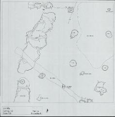
H2 plans, including CH71 cuttings BI, BV, BVI and BVII
CH71 trail cuttings centred on this square (slightly off site grid alignment. Whole square then opened again in CH74 as H2. BI: approx on site grid in H2, extends 2m into J2. 8m E-W, 5m N-S. BV to N and BVI to E both separated by 50 cms baulks. BV: Approx on site grid in H2, extending 2m into J2. 8m E-W, 5m N-S. BI to S and BVII to E both separated by 50 cms baulks. BVI: Approx on site grid in H2, extends into G2. 8m E-W, 5m N-S. BVII to N and BI to W both separated by 50 cms baulks. BVII: Approx on site grid in H2, extends into G2. 8m E-W, 5m N-S. BVI to S and BV to W both separated by 50 cms baulks. No plans for CH71 outside supervisor book, but picked up by H2 Feature Plan.